
1950 Map of Antelope Peak
USGS Topo · Published 1952About this map
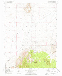
Antelope Peak and the surrounding Antelope Range dominate this mid-century topographic record, where the high desert terrain transitions sharply into the southern reach of the Escalante Desert. The landscape is defined by its water sources and distinct geological markers, such as the prominent flat-topped Table Butte to the north and the clustered Three Peaks in the east.
Find a feature on this map
11 named features on this map. Tap any name to fly to it.
Don’t see what you’re looking for? This feature index may not catch every label — zoom into the map to look around manually.
Map Details
Editions of this 1950 Antelope Peak Map
2 editions found
Other maps of this area

1885 · St. George
USGS Topo · 1:250,000

1891 · St. George
USGS Topo · 1:250,000

1950 · Iron Mountain
USGS Topo · 1:62,500

1950 · Silver Peak
USGS Topo · 1:24,000

1950 · Desert Mound
USGS Topo · 1:24,000

1950 · Avon SE
USGS Topo · 1:24,000

1951 · Avon SE
USGS Topo · 1:24,000

1951 · Silver Peak
USGS Topo · 1:24,000
1951 · Desert Mound
USGS Topo · 1:24,000

1951 · Avon
USGS Topo · 1:24,000