
1950 Map of Avon SE
USGS Topo · Published 1979About this map
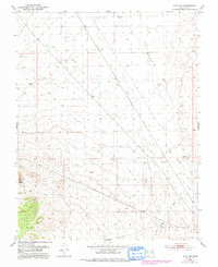
The Union Pacific railroad cuts a sharp diagonal across this arid Iron County landscape, marking the industrial connectivity of the mid-century West. To the southwest, the Antelope Range rises sharply, punctuated by the prominent Three Peaks and Upper Pt. The terrain is defined by complex drainage systems, including the uniquely named Dick Palmer Wash and its confluence at Tucker Dick Palmer Wash, alongside Iron Springs Creek. Scattered windmills suggest the ongoing importance of livestock and water management in this high-desert environment. The presence of Antelope Road and various land lines indicate a surveyed but sparsely populated territory, where geography is dictated by the availability of water and the path of the rail. These 1950 surveys, later updated with 1970s aerial data, provide a clear record of the area's infrastructure before significant modern expansion.
Find a feature on this map
11 named features on this map. Tap any name to fly to it.
Don’t see what you’re looking for? This feature index may not catch every label — zoom into the map to look around manually.
Map Details
Editions of this 1950 Avon SE Map
2 editions found
Other maps of this area

1885 · St. George
USGS Topo · 1:250,000

1891 · St. George
USGS Topo · 1:250,000

1949 · Cedar City NW
USGS Topo · 1:24,000

1950 · Cedar City NW
USGS Topo · 1:24,000

1950 · Antelope Peak
USGS Topo · 1:24,000

1950 · Enoch
USGS Topo · 1:62,500

1950 · Iron Mountain
USGS Topo · 1:62,500

1950 · Cedar City
USGS Topo · 1:62,500

1950 · The Three Peaks
USGS Topo · 1:24,000

1950 · Silver Peak
USGS Topo · 1:24,000