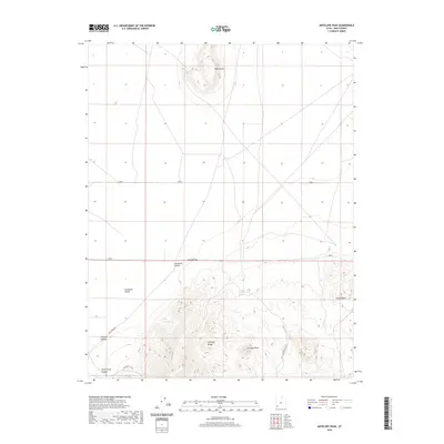
2020 Map of Antelope Peak
USGS Topo · Published 2020About this map
Antelope Peak and the Antelope Range dominate the southern portion of this landscape, rising above the arid floor where the Escalante Desert meets the Escalante Valley. This recent survey illustrates a terrain defined by dramatic relief and isolated water sources, vital for understanding the historical movement through this part of Iron County. To the north, the prominent Table Butte stands as a distinct landmark above the desert flats. Significant drainage features like Chloride Canyon and Sand Spring Canyon cut through the mountains, while rare water points such as Antelope Springs and Rock Spring provide critical reference for the high-desert environment. Rural transportation routes, including Sand Spring Rd, follow the natural contours of Urie Hollow and the valley floor, connecting the scattered topographic landmarks of the basin-and-range country.
Find a feature on this map
13 named features on this map. Tap any name to fly to it.
Don’t see what you’re looking for? This feature index may not catch every label — zoom into the map to look around manually.
Map Details
Editions of this 2020 Antelope Peak Map
This is the sole edition of this map. No revisions or reprints were ever made.
Other maps of this area

1885 · St. George
USGS Topo · 1:250,000

1891 · St. George
USGS Topo · 1:250,000

1950 · Antelope Peak
USGS Topo · 1:24,000

1950 · Iron Mountain
USGS Topo · 1:62,500

1950 · Silver Peak
USGS Topo · 1:24,000

1950 · Desert Mound
USGS Topo · 1:24,000

1950 · Avon SE
USGS Topo · 1:24,000

1951 · Avon SE
USGS Topo · 1:24,000

1951 · Silver Peak
USGS Topo · 1:24,000
1951 · Desert Mound
USGS Topo · 1:24,000