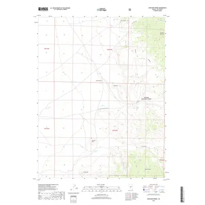
2018 Map of Antelope Spring
USGS Topo · Published 2018About this map
Toiyabe National Forest dominates the high desert landscape of this central Nevada survey, where the Monitor Range and McKinney Mountains converge. The terrain is defined by its vital water sources, with isolated points like Antelope Spring, Nickel Spring, and Wood Chopper Spring serving as critical landmarks in an otherwise arid basin. These springs, alongside drainages such as Willow Cr, indicate the historical importance of water management for livestock and transient travel through Nye County. Prominent volcanic and erosional features including Mexican Butte, Antelope Peak, and Kinney Peak provide clear navigational markers. The presence of Mine Canyon suggests the region's long-standing connection to Great Basin prospecting, while the Natl Forest Develop Road 235 Rd provides the primary access through the Big White Sage flats.
Find a feature on this map
18 named features on this map. Tap any name to fly to it.
Don’t see what you’re looking for? This feature index may not catch every label — zoom into the map to look around manually.
Map Details
Editions of this 2018 Antelope Spring Map
This is the sole edition of this map. No revisions or reprints were ever made.
Other maps of this area

1907 · Tonopah
USGS Topo · 1:250,000

1908 · Tonopah
USGS Topo · 1:250,000

1956 · Tonopah
USGS Topo · 1:250,000

1959 · Tonopah
USGS Topo · 1:250,000

1961 · Tonopah
USGS Topo · 1:62,500

1962 · Tonopah
USGS Topo · 1:250,000

1963 · Baxter Spring
USGS Topo · 1:62,500

1971 · Antelope Spring
USGS Topo · 1:24,000

1971 · Saulsbury Basin
USGS Topo · 1:24,000
1971 · Big Ten Peak West
USGS Topo · 1:24,000