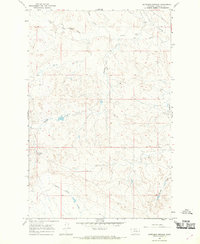
1965 Map of Antelope Springs
USGS Topo · Published 1969About this map
Antelope Springs sits within a landscape defined by an intricate network of intermittent watercourses and landforms in Garfield County. The terrain is dominated by the broad drainage patterns of Little Dry Creek and its many tributaries, including Horse Creek and Antelope Creek. High points like McGraw Butte offer significant elevation above the winding coulees that carve through this part of the Montana plains. The map reveals a land structured by ranching and grazing, with fine red dashed lines indicating property fence lines and a sparse distribution of unimproved roads and trails. The naming of Russian Frank Coulee suggests a history of local figures or early homesteaders whose presence is etched into the geographic nomenclature of this drainage basin. Deep erosion patterns are evident in the southeastern corner along Badlands Coulee, illustrating the characteristic topography of the region's semi-arid environment during the mid-1960s.
Find a feature on this map
12 named features on this map. Tap any name to fly to it.
Don’t see what you’re looking for? This feature index may not catch every label — zoom into the map to look around manually.
Map Details
Editions of this 1965 Antelope Springs Map
This is the sole edition of this map. No revisions or reprints were ever made.
Other maps of this area

1954 · Jordan
USGS Topo · 1:250,000

1954 · Forsyth
USGS Topo · 1:250,000

1956 · Jordan
USGS Topo · 1:250,000

1957 · Forsyth
USGS Topo · 1:250,000

1958 · Jordan
USGS Topo · 1:250,000

1958 · Forsyth
USGS Topo · 1:250,000

1964 · Jordan
USGS Topo · 1:250,000

1965 · Black Hills
USGS Topo · 1:24,000

1965 · Needle Butte Reservoir
USGS Topo · 1:24,000

1965 · Dice Dam
USGS Topo · 1:24,000