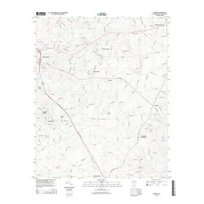
2014 Map of Antioch
USGS Topo · Published 2014About this map
Lancaster and its eastern environs are defined by a network of rural settlements and watercourses in this contemporary survey of the South Carolina piedmont. Small community hubs like Antioch, Elgin, and Pleasant Dale anchor the landscape, while larger infrastructure is represented by the Lancaster Reservoir and the Kirk Air Base Airport. The area is bisected by major thoroughfares such as SC-9 and the Kershaw-Camden Hwy, which connect these dispersed crossroads.
Find a feature on this map
170 named features on this map. Tap any name to fly to it.
Don’t see what you’re looking for? This feature index may not catch every label — zoom into the map to look around manually.
Map Details
Editions of this 2014 Antioch Map
This is the sole edition of this map. No revisions or reprints were ever made.
Other maps of this area

1941 · Spartanburg
USGS Topo · 1:250,000

1953 · Spartanburg
USGS Topo · 1:250,000

1960 · Spartanburg
USGS Topo · 1:250,000

1963 · Spartanburg
USGS Topo · 1:250,000

1964 · Spartanburg
USGS Topo · 1:250,000

1968 · Van Wyck
USGS Topo · 1:24,000

1968 · Lancaster SE
USGS Topo · 1:24,000

1968 · Heath Springs
USGS Topo · 1:24,000
1969 · Kershaw
USGS Topo · 1:24,000

1969 · Antioch
USGS Topo · 1:24,000