
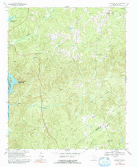
1968 Map of Lancaster SE
USGS Topo · Published 1971About this map
The Catawba River corridor defines the western edge of this landscape, where the waters of the Fishing Creek Reservoir and Cedar Creek Reservoir collect behind early hydroelectric developments. The interior terrain is a network of ridges and drainages including Camp Creek, Dry Creek, and Rocky Creek, which shaped the placement of local settlements and crossroads. Local life in the late 1960s centered on intersection communities like Cauthens Crossroads and Blakley Crossroads, and a high density of country churches such as St Pauls Ch, New Hope Ch, and Gethsemane Ch. This period shows the transition from a traditional rural economy to one increasingly industrial, evidenced by several claypits and a Quarry dotting the hillsides. The map also captures the jurisdictional meeting point of three counties, with the Lancaster-Kershaw and Chester-Lancaster lines crossing through these river-fed woodlands.
Find a feature on this map
33 named features on this map. Tap any name to fly to it.
Don’t see what you’re looking for? This feature index may not catch every label — zoom into the map to look around manually.
Map Details
Editions of this 1968 Lancaster SE Map
2 editions found
Other maps of this area

1935 · Camden
USGS Topo · 1:48,000

1938 · Camden
USGS Topo · 1:62,500

1941 · Spartanburg
USGS Topo · 1:250,000

1942 · Camden
USGS Topo · 1:125,000

1953 · Spartanburg
USGS Topo · 1:250,000

1960 · Spartanburg
USGS Topo · 1:250,000

1963 · Spartanburg
USGS Topo · 1:250,000

1964 · Spartanburg
USGS Topo · 1:250,000

1968 · Heath Springs
USGS Topo · 1:24,000

1969 · Antioch
USGS Topo · 1:24,000