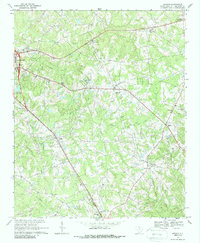
1969 Map of Antioch
USGS Topo · Published 1988About this map
Lancaster and its eastern rural surroundings are defined by a network of local crossroads and community churches in this late 1960s survey. The landscape is carved by numerous waterways including Gills Creek, Turkey Creek, and Bear Creek, which flow through a region primarily dedicated to agriculture and small-scale resource extraction. Evidence of local industry is visible through multiple claypits and sandpits scattered across the terrain. The Southern railroad line cuts a path through the southern half of the sheet, connecting settlements like Elgin and Primus. Local spiritual and community life is anchored by several named houses of worship, such as Trinity Ch, Oak Ridge Ch, and Hopewell Ch. Genealogists may find particular interest in the noted burial grounds like Caskey Cem and Pilgrim Ch Cem, which serve as quiet markers of the area's established family histories.
Find a feature on this map
37 named features on this map. Tap any name to fly to it.
Don’t see what you’re looking for? This feature index may not catch every label — zoom into the map to look around manually.
Map Details
Editions of this 1969 Antioch Map
2 editions found
Other maps of this area

1941 · Spartanburg
USGS Topo · 1:250,000

1953 · Spartanburg
USGS Topo · 1:250,000

1960 · Spartanburg
USGS Topo · 1:250,000

1963 · Spartanburg
USGS Topo · 1:250,000

1964 · Spartanburg
USGS Topo · 1:250,000

1968 · Van Wyck
USGS Topo · 1:24,000

1968 · Lancaster SE
USGS Topo · 1:24,000

1968 · Heath Springs
USGS Topo · 1:24,000
1969 · Kershaw
USGS Topo · 1:24,000

1969 · Antioch
USGS Topo · 1:24,000