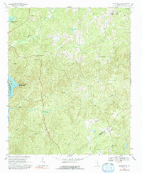
1968 Map of Lancaster SE
USGS Topo · Published 1992About this map
Cauthens Crossroads and Blakley Crossroads anchor this landscape of the South Carolina Piedmont, where the Catawba River and its major impoundments, the Fishing Creek Reservoir and Cedar Creek Reservoir, shape the western boundary. The terrain is deeply dissected by a network of waterways including Camp Creek, Dry Creek, and McDowell Creek, which historically dictated the placement of rural centers. A strong pattern of community identity is visible through the numerous country churches and cemeteries that dot the ridges, such as Mt Carmel Ch, St Pauls Ch, and Cedar Rock Ch. The map also documents the industrial footprint of the era, noting several Claypit sites and a Quarry, reflecting the local reliance on the region's geological resources alongside established agricultural crossroads.
Find a feature on this map
35 named features on this map. Tap any name to fly to it.
Don’t see what you’re looking for? This feature index may not catch every label — zoom into the map to look around manually.
Map Details
Editions of this 1968 Lancaster SE Map
2 editions found
Other maps of this area

1935 · Camden
USGS Topo · 1:48,000

1938 · Camden
USGS Topo · 1:62,500

1941 · Spartanburg
USGS Topo · 1:250,000

1942 · Camden
USGS Topo · 1:125,000

1953 · Spartanburg
USGS Topo · 1:250,000

1960 · Spartanburg
USGS Topo · 1:250,000

1963 · Spartanburg
USGS Topo · 1:250,000

1964 · Spartanburg
USGS Topo · 1:250,000

1968 · Lancaster SE
USGS Topo · 1:24,000

1968 · Heath Springs
USGS Topo · 1:24,000