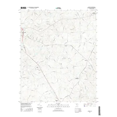
2017 Map of Antioch
USGS Topo · Published 2017About this map
Kirk Air Base sits at the heart of this landscape in Lancaster County, surrounded by a network of rural crossroads and agricultural land. The eastern edge of Lancaster transitions into smaller settlements like Elgin and Antioch, while the surrounding countryside is defined by numerous family-named landmarks and water bodies. Significant hydrologic features include Lancaster Reservoir, Betheas Pond, and Burnetts Pond, which feed into local drainage systems like Turkey Quarter Cr and Bear Cr. This 2017 record illustrates the modern intersection of aviation history and traditional Piedmont geography, where historic cemeteries such as Caskey Cem and Baskins Cem remain preserved alongside the expanding residential footprint of the county. The road network connects established points like Rich Hill Crossroads and Dwight Crossroads, reflecting the enduring settlement patterns of this South Carolina region.
Find a feature on this map
152 named features on this map. Tap any name to fly to it.
Don’t see what you’re looking for? This feature index may not catch every label — zoom into the map to look around manually.
Map Details
Editions of this 2017 Antioch Map
This is the sole edition of this map. No revisions or reprints were ever made.
Other maps of this area

1941 · Spartanburg
USGS Topo · 1:250,000

1953 · Spartanburg
USGS Topo · 1:250,000

1960 · Spartanburg
USGS Topo · 1:250,000

1963 · Spartanburg
USGS Topo · 1:250,000

1964 · Spartanburg
USGS Topo · 1:250,000

1968 · Van Wyck
USGS Topo · 1:24,000

1968 · Lancaster SE
USGS Topo · 1:24,000

1968 · Heath Springs
USGS Topo · 1:24,000
1969 · Kershaw
USGS Topo · 1:24,000

1969 · Antioch
USGS Topo · 1:24,000