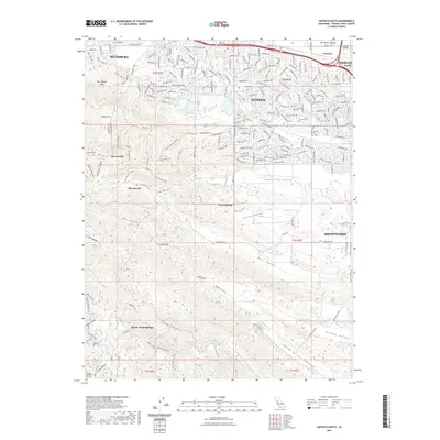
2021 Map of Antioch South
USGS Topo · Published 2021About this map
Rose Hill Cem and the surrounding mining heritage of the Diablo Range define the western reaches of this 2021 survey. The landscape transitions from the dense residential grids of Antioch and Pittsburg into the preserved open spaces of the East Bay hills. Historical mining sites are represented by the former settlements of Somersville and Stewartville, which are now integrated into a network of hiking paths like the Nortonville Trl and Corcoran Mine Trl. Significant water infrastructure, including the Mokelumne Aqueduct and Contra Costa Canal, moves through the northern flats toward the Contra Loma Reservoir. South of Lone Tree Valley, the terrain becomes increasingly complex, marked by deep canyons such as Oil Canyon and Dark Canyon, and the thermal features of Marsh Creek Springs.
Find a feature on this map
67 named features on this map. Tap any name to fly to it.
Don’t see what you’re looking for? This feature index may not catch every label — zoom into the map to look around manually.
Map Details
Editions of this 2021 Antioch South Map
This is the sole edition of this map. No revisions or reprints were ever made.
Other maps of this area

1896 · Mt. Diablo
USGS Topo · 1:62,500

1898 · Mt. Diablo
USGS Topo · 1:62,500

1907 · Antioch
USGS Topo · 1:62,500

1908 · Antioch
USGS Topo · 1:62,500

1910 · Jersey
USGS Topo · 1:31,680

1911 · Byron Hot Springs
USGS Topo · 1:31,680

1914 · Brentwood
USGS Topo · 1:31,680

1916 · Lone Tree Valley
USGS Topo · 1:31,680

1916 · Byron Hot Springs
USGS Topo · 1:31,680

1916 · Byron
USGS Topo · 1:62,500