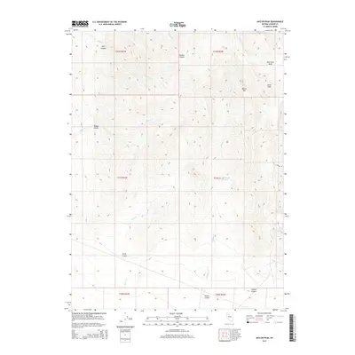
2014 Map of Antler Peak
USGS Topo · Published 2014About this map
Antler Peak and the high ridges of Battle Mtn dominate this interior portion of the Nevada range landscape. The topography is defined by a series of steep drainages, including Timber Canyon and Trenton Canyon, which channel seasonal water from the heights down toward the flats. Modern water management is visible at the Willow Creek Reservoir, catching runoff from the northern slopes. The map also reveals the geographic footprints of historical and active land use through names like Galena Cyn and Copper Canyon, suggesting a legacy of mineral exploration and extraction in these canyons. Between the peaks, features like Wild Horse Basin indicate the high-altitude pockets of the terrain, while numerous creek systems like Mill Cr and Rock Cr carve the deep recesses of Mill Canyon and Rocky Canyon.
Find a feature on this map
23 named features on this map. Tap any name to fly to it.
Don’t see what you’re looking for? This feature index may not catch every label — zoom into the map to look around manually.
Map Details
Editions of this 2014 Antler Peak Map
This is the sole edition of this map. No revisions or reprints were ever made.
Other maps of this area

1932 · Sonoma Range
USGS Topo · 1:250,000

1939 · Sonoma Range
USGS Topo · 1:250,000

1940 · Antler Peak
USGS Topo · 1:62,500

1943 · Antler Peak
USGS Topo · 1:62,500

1955 · Winnemucca
USGS Topo · 1:250,000

1958 · Winnemucca
USGS Topo · 1:250,000

1961 · McCoy
USGS Topo · 1:62,500

1962 · Winnemucca
USGS Topo · 1:250,000

1962 · Buffalo Springs
USGS Topo · 1:62,500
1965 · Cherry Creek NE
USGS Topo · 1:24,000