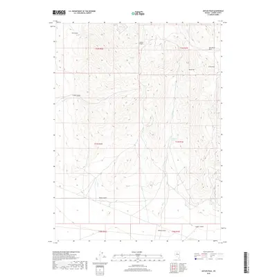
2018 Map of Antler Peak
USGS Topo · Published 2018About this map
Antler Peak and the high ridges of Battle Mtn dominate this 2018 survey of central Lander County, where steep drainage systems define the high desert topography. The map illustrates a network of prominent seasonal waterways and valleys, including Trenton Canyon and Mill Canyon to the north, and Rocky Canyon and Willow Canyon to the south. Central to the area's hydrology is the Willow Cr Reservoir, fed by Willow Cr as it flows through the basin. This USGS survey provides a contemporary view of the public land survey system, showing the township and range divisions of t31n r43e and surrounding sections. The terrain transitions from the high elevations of Wild Horse Basin down toward Copper Canyon, reflecting the area's typical Great Basin geography of isolated mountain ranges separated by arid drainages like Rock Cr and Timber Cr.
Find a feature on this map
22 named features on this map. Tap any name to fly to it.
Don’t see what you’re looking for? This feature index may not catch every label — zoom into the map to look around manually.
Map Details
Editions of this 2018 Antler Peak Map
This is the sole edition of this map. No revisions or reprints were ever made.
Other maps of this area

1932 · Sonoma Range
USGS Topo · 1:250,000

1939 · Sonoma Range
USGS Topo · 1:250,000

1940 · Antler Peak
USGS Topo · 1:62,500

1943 · Antler Peak
USGS Topo · 1:62,500

1955 · Winnemucca
USGS Topo · 1:250,000

1958 · Winnemucca
USGS Topo · 1:250,000

1961 · McCoy
USGS Topo · 1:62,500

1962 · Winnemucca
USGS Topo · 1:250,000

1962 · Buffalo Springs
USGS Topo · 1:62,500
1965 · Cherry Creek NE
USGS Topo · 1:24,000