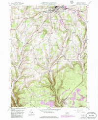
1946 Map of Antrim
USGS Topo · Published 1986About this map
The borough of Wellsboro anchors this Tioga County landscape, shown here as it transitioned through the mid-20th century. The northern portion of the map reveals the town's early suburban and civic development, including the Wellsboro Country Club and the County Home. Moving south, the terrain becomes increasingly defined by the steep hollows and ridges of the Tioga State Forest and State Game Lands No 268. A distinctive industrial and transit corridor follows Stony Fork, where the NYC RR line winds alongside small rural hubs like Draper.
Find a feature on this map
41 named features on this map. Tap any name to fly to it.
Don’t see what you’re looking for? This feature index may not catch every label — zoom into the map to look around manually.
Map Details
Editions of this 1946 Antrim Map
5 editions found
Other maps of this area

1900 · Tioga
USGS Topo · 1:62,500

1900 · Elkland
USGS Topo · 1:62,500

1902 · Tioga
USGS Topo · 1:62,500

1925 · Blossburg
USGS Topo · 1:62,500

1927 · Blossburg
USGS Topo · 1:62,500

1944 · Blossburg
USGS Topo · 1:62,500

1946 · Tiadaghton
USGS Topo · 1:24,000

1946 · Antrim
USGS Topo · 1:62,500

1946 · Cedar Run
USGS Topo · 1:24,000

1946 · Antrim
USGS Topo · 1:24,000
Featured Places
- Wellsboro, PA
- Morris Township, PA
- Duncan Township, PA
- Stony Fork, Delmar Township
- Pitts, Charleston Township