1981 Map of Anza
USGS Topo · Published 1982About this map
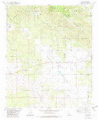
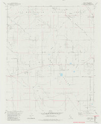
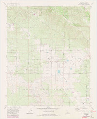
Anza serves as the focal point of this high-desert landscape in the early 1980s, where the convergence of Cahuilla Valley, Durasno Valley, and Terwilliger Valley meets the rising slopes of Thomas Mountain. The map reveals a complex mosaic of land use, with the San Bernardino National Forest bordering the Ramona Indian Reservation and Cahuilla Indian Reservation. This intersection of forest service land and tribal territories is marked by a network of seasonal water sources such as Hog Lake and numerous wells and springs that sustain the local ranching and residential sites. Notable local infrastructure includes the Hamilton Sch and several recreation sites like the Tool Box Spring Campground, reflecting the area's role as a gateway between the San Jacinto mountains and the desert floor. The distribution of small settlements like Costo and various trailer parks suggests a community shaped by its topography and the paths of Cahuilla Creek and Bautista Canyon.
Find a feature on this map
36 named features on this map. Tap any name to fly to it.
Don’t see what you’re looking for? This feature index may not catch every label — zoom into the map to look around manually.
Map Details
Editions of this 1981 Anza Map
3 editions found
Other maps of this area

1901 · Southern California Sheet No. 1
USGS Topo · 1:250,000

1901 · San Jacinto
USGS Topo · 1:125,000

1903 · Ramona
USGS Topo · 1:125,000

1904 · Southern California Sheet No. 2
USGS Topo · 1:250,000

1904 · Southern California Sheet No. 1
USGS Topo · 1:250,000

1939 · Warner Springs
USGS Topo · 1:62,500

1939 · Palomar Mountain
USGS Topo · 1:62,500

1940 · Hemet Reservoir
USGS Topo · 1:62,500

1942 · Hemet Reservoir
USGS Topo · 1:62,500

1942 · Hemet
USGS Topo · 1:62,500