1981 Map of Anza
USGS Topo · Published 1988About this map
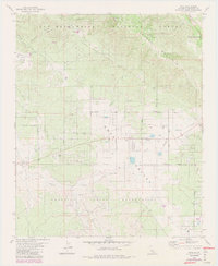
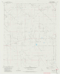
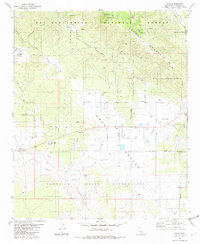
The high mountain valleys of southern Riverside County are defined here by a series of distinct basins, including Anza Valley, Cahuilla Valley, and Terwilliger Valley. This 1980s landscape shows the intersection of the San Bernardino National Forest with sovereign tribal lands, specifically the Cahuilla Indian Reservation and Ramona Indian Reservation. The settlement patterns revolve around the communities of Anza and Hamilton, where a network of rural routes like Bautista Road and Contreras Road connect scattered wells and small clusters of development. Evidence of local recreation and transportation infrastructure is present in the numerous campgrounds, such as Tool Box Spring Campground, and a localized Landing Strip. The presence of a small Cem near Cahuilla provides a focal point for genealogical interest, while the rugged terrain of Thomas Mountain looms over the valley floors.
Find a feature on this map
58 named features on this map. Tap any name to fly to it.
Don’t see what you’re looking for? This feature index may not catch every label — zoom into the map to look around manually.
Map Details
Editions of this 1981 Anza Map
3 editions found
Other maps of this area

1901 · Southern California Sheet No. 1
USGS Topo · 1:250,000

1901 · San Jacinto
USGS Topo · 1:125,000

1903 · Ramona
USGS Topo · 1:125,000

1904 · Southern California Sheet No. 2
USGS Topo · 1:250,000

1904 · Southern California Sheet No. 1
USGS Topo · 1:250,000

1939 · Warner Springs
USGS Topo · 1:62,500

1939 · Palomar Mountain
USGS Topo · 1:62,500

1940 · Hemet Reservoir
USGS Topo · 1:62,500

1942 · Hemet Reservoir
USGS Topo · 1:62,500

1942 · Hemet
USGS Topo · 1:62,500