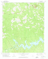
1972 Map of Aonia
USGS Topo · Published 1974About this map
The Little River and the expansive reaches of Clark Hill Lake dominate the southern landscape of this 1970s survey, marking a region shaped by both its natural drainage and mid-century water management. Along the northern heights, Graves Mtn stands near the industrial activity of the Ship Mine and its associated Tailings Pond, indicating a local economy tied to the land's geological resources. The rural character of Wilkes County is further defined by its tight-knit community structures, where small settlements like Aonia and Adasburg serve as anchors for a network of country roads.
Find a feature on this map
30 named features on this map. Tap any name to fly to it.
Don’t see what you’re looking for? This feature index may not catch every label — zoom into the map to look around manually.
Map Details
Editions of this 1972 Aonia Map
2 editions found
Other maps of this area

1892 · Mc Cormick
USGS Topo · 1:125,000

1906 · Crawfordville
USGS Topo · 1:125,000

1912 · Mc Cormick
USGS Topo · 1:125,000

1921 · Appling
USGS Topo · 1:62,500

1943 · Appling
USGS Topo · 1:62,500

1953 · Athens
USGS Topo · 1:250,000

1954 · Metasville
USGS Topo · 1:24,000

1955 · Tignall
USGS Topo · 1:24,000

1958 · Athens
USGS Topo · 1:250,000

1959 · Athens
USGS Topo · 1:250,000