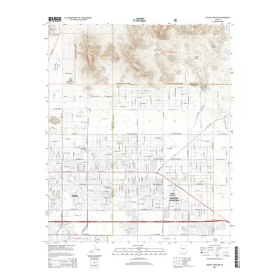
2014 Map of Apache Junction
USGS Topo · Published 2014About this map
Apache Junction and the eastern edge of Mesa meet at the desert foothills where urban expansion intersects the protected wilderness of the Tonto National Forest. This 2014 survey documents a landscape of planned residential developments like Ruidoso and Palm Springs positioned against the stark relief of the Goldfield Mountains and Usery Mountains. The transit infrastructure of the modern era is clearly visible, from the major thoroughfare of Apache Trail to the massive engineering of the Central Arizona Project Aqueduct cutting across the southwestern terrain. Local geography is defined by prominent landmarks such as Signal Butte and the winding paths of Bulldog Canyon and Siphon Draw, which drain the high ground toward the populated valley floor. The map also captures the boundaries of Usery Mountain Park, highlighting the region's balance between residential growth and recreational land use.
Find a feature on this map
53 named features on this map. Tap any name to fly to it.
Don’t see what you’re looking for? This feature index may not catch every label — zoom into the map to look around manually.
Map Details
Editions of this 2014 Apache Junction Map
This is the sole edition of this map. No revisions or reprints were ever made.
Other maps of this area

1900 · Florence
USGS Topo · 1:125,000

1902 · Florence
USGS Topo · 1:125,000

1904 · Desert Well
USGS Topo · 1:62,500

1904 · Ft. McDowell
USGS Topo · 1:62,500

1906 · Ft. McDowell
USGS Topo · 1:62,500

1906 · Desert Well
USGS Topo · 1:62,500

1907 · Roosevelt
USGS Topo · 1:125,000

1909 · Four Peaks
USGS Topo · 1:125,000

1912 · Roosevelt
USGS Topo · 1:125,000

1930 · Cave Creek
USGS Topo · 1:125,000