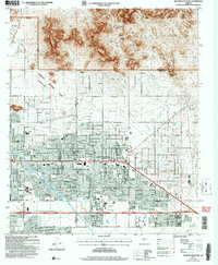
2004 Map of Apache Junction
USGS Topo · Published 2007About this map
Apache Junction serves as the gateway to the high desert, where the residential grids of the Valley meet the rising slopes of the Gold Field Mountains. This 2004 revision reveals the significant suburban expansion occurring along the Maricopa and Pinal county line, with dense development bordering the protected lands of the Tonto National Forest. The presence of the Central Arizona Project Canal and the Gila and Salt River Base Line illustrates the heavy engineering required to support desert habitation and agricultural history. Local landmarks like the Superstition Mountain Museum and Superstition Air Park anchor the community, while the northern terrain is marked by traditional western features including Bulldog Canyon and the Rio Salado Gun Club.
Find a feature on this map
46 named features on this map. Tap any name to fly to it.
Don’t see what you’re looking for? This feature index may not catch every label — zoom into the map to look around manually.
Map Details
Editions of this 2004 Apache Junction Map
This is the sole edition of this map. No revisions or reprints were ever made.
Other maps of this area

1900 · Florence
USGS Topo · 1:125,000

1902 · Florence
USGS Topo · 1:125,000

1904 · Desert Well
USGS Topo · 1:62,500

1904 · Ft. McDowell
USGS Topo · 1:62,500

1906 · Ft. McDowell
USGS Topo · 1:62,500

1906 · Desert Well
USGS Topo · 1:62,500

1907 · Roosevelt
USGS Topo · 1:125,000

1909 · Four Peaks
USGS Topo · 1:125,000

1912 · Roosevelt
USGS Topo · 1:125,000

1930 · Cave Creek
USGS Topo · 1:125,000