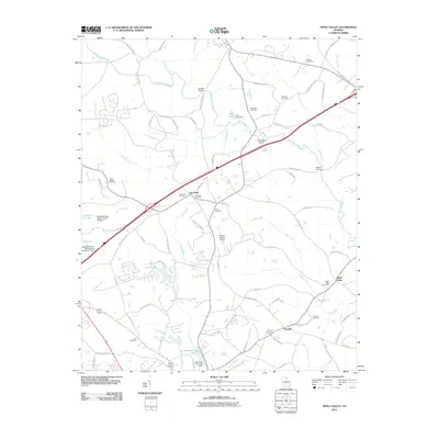
2011 Map of Apple Valley
USGS Topo · Published 2011About this map
The North Oconee River winds through this Piedmont landscape, defining a rural corridor between the settlements of Dry Pond and Thyatira. By the early 21st century, the area maintained its agricultural character while supporting modern infrastructure like the Jackson County Airport. Local history is deeply embedded in the land, evidenced by numerous family and community burial grounds such as Cave Springs Cemetery, Oconee Cemetery, and Bennett Cemetery. The river is a central geographic feature, crossed at Candler Bridge and Woods Bridge, and is fed by several tributaries including Candler Creek and Gravelly Creek. In the southern portion of the quadrangle, water management is visible through the Jefferson City Lake and its associated dam. This map preserves the locations of early 20th-century landmarks like Hurricane Shoal and the community of Apple Valley, providing a detailed record of Jackson County's evolving landscape of roads and water resources.
Find a feature on this map
93 named features on this map. Tap any name to fly to it.
Don’t see what you’re looking for? This feature index may not catch every label — zoom into the map to look around manually.
Map Details
Editions of this 2011 Apple Valley Map
This is the sole edition of this map. No revisions or reprints were ever made.
Other maps of this area

1891 · Gainesville
USGS Topo · 1:125,000

1891 · Carnesville
USGS Topo · 1:125,000

1954 · Greenville
USGS Topo · 1:250,000

1958 · Greenville
USGS Topo · 1:250,000

1964 · Commerce
USGS Topo · 1:24,000

1964 · Maysville
USGS Topo · 1:24,000
1964 · Winder North
USGS Topo · 1:24,000
1964 · Nicholson
USGS Topo · 1:24,000

1964 · Pendergrass
USGS Topo · 1:24,000
1964 · Jefferson
USGS Topo · 1:24,000