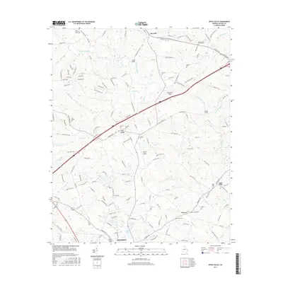
2017 Map of Apple Valley
USGS Topo · Published 2017About this map
Jefferson and Maysville anchor this 2017 survey of Jackson County, showcasing a landscape where modern infrastructure meets long-standing rural community centers. The North Oconee River and its various tributaries like Stockton Cr and Candler Cr define the local drainage, while the presence of the Jackson County Airport and Interstate 85 indicates the region's contemporary connectivity. The map is particularly dense with genealogical sites, including the Thyatira Cem, Wilson Chapel Methodist Cem, and the Unity Christian Church Cem in the northwest corner.
Find a feature on this map
159 named features on this map. Tap any name to fly to it.
Don’t see what you’re looking for? This feature index may not catch every label — zoom into the map to look around manually.
Map Details
Editions of this 2017 Apple Valley Map
This is the sole edition of this map. No revisions or reprints were ever made.
Other maps of this area

1891 · Gainesville
USGS Topo · 1:125,000

1891 · Carnesville
USGS Topo · 1:125,000

1954 · Greenville
USGS Topo · 1:250,000

1958 · Greenville
USGS Topo · 1:250,000

1964 · Commerce
USGS Topo · 1:24,000

1964 · Maysville
USGS Topo · 1:24,000
1964 · Winder North
USGS Topo · 1:24,000
1964 · Nicholson
USGS Topo · 1:24,000

1964 · Pendergrass
USGS Topo · 1:24,000
1964 · Jefferson
USGS Topo · 1:24,000