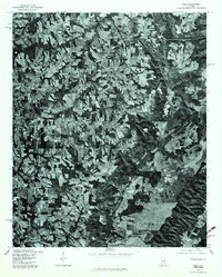
1975 Map of Arab
USGS Topo · Published 1983About this map
Arab serves as the primary population center on this mid-1970s orthophotoquad, which utilizes aerial imagery to reveal the complex mosaic of agricultural clearings and dense woodlands across this portion of Marshall County. The orthophoto format, produced by the Soil Conservation Service and the Geological Survey, provides a unique look at land-use patterns that traditional line maps might obscure. To the north, the small settlement of Scant City is visible, while Red Hill occupies the southern reaches of the sheet. The eastern edge of the quadrangle is defined by the expansive waters of Guntersville Lake, showing the intricate shoreline and the way the topography drops toward the Tennessee River valley. This 1975 perspective is particularly valuable for researchers tracing the physical evolution of local farmsteads and rural infrastructure before modern suburban expansion.
Find a feature on this map
4 named features on this map. Tap any name to fly to it.
Don’t see what you’re looking for? This feature index may not catch every label — zoom into the map to look around manually.
Map Details
Editions of this 1975 Arab Map
2 editions found
Other maps of this area

1885 · Gadsden
USGS Topo · 1:125,000

1888 · Cullman
USGS Topo · 1:125,000

1888 · Gadsden
USGS Topo · 1:125,000

1892 · Cullman
USGS Topo · 1:125,000

1892 · Gadsden
USGS Topo · 1:125,000

1895 · Gadsden
USGS Topo · 1:125,000

1903 · Gadsden
USGS Topo · 1:125,000

1936 · Guntersville
USGS Topo · 1:24,000

1936 · Guntersville Dam
USGS Topo · 1:24,000

1936 · Hulaco
USGS Topo · 1:24,000