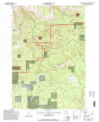
1995 Map of Arbuckle Mountain
USGS Topo · Published 1998About this map
Umatilla National Forest encompasses this high-altitude landscape in the mid-1990s, where traditional ranching and timber heritage is etched into the terrain. The presence of the Arbuckle Corral (Site) and Yokum Cabin suggests a history of seasonal grazing and forest management, while labels like Blue Mountain Ditch indicate early efforts to manage water resources across these ridges.
Find a feature on this map
61 named features on this map. Tap any name to fly to it.
Don’t see what you’re looking for? This feature index may not catch every label — zoom into the map to look around manually.
Map Details
Editions of this 1995 Arbuckle Mountain Map
This is the sole edition of this map. No revisions or reprints were ever made.
Other maps of this area

1953 · Pendleton
USGS Topo · 1:250,000

1956 · Pendleton
USGS Topo · 1:250,000

1967 · Freezeout Ridge
USGS Topo · 1:24,000

1968 · Hoodlum Canyon
USGS Topo · 1:24,000

1968 · Skinners Fork
USGS Topo · 1:24,000

1969 · Summerfield Ridge
USGS Topo · 1:24,000

1969 · Lake Penland
USGS Topo · 1:24,000

1969 · Thompson Flat
USGS Topo · 1:24,000

1969 · Arbuckle Mtn
USGS Topo · 1:24,000
1969 · Matlock Prairie
USGS Topo · 1:24,000