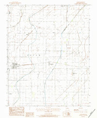
1983 Map of Arbyrd
USGS Topo · Published 1984About this map
The Missouri Bootheel's agricultural grid is meticulously detailed in this early 1980s provisional study, showing the hydraulic transformation of the lowlands into productive acreage. Arbyrd serves as a central hub, surrounded by smaller settlements like Hollywood, Bucoda, and Europa. The landscape is defined by an extensive network of drainage channels, including the Honey Cypress Ditch, Cypress Ditch, and Buffalo Creek, which redirected the natural waters of Pole Cat Slough to allow for settlement and farming.
Find a feature on this map
26 named features on this map. Tap any name to fly to it.
Don’t see what you’re looking for? This feature index may not catch every label — zoom into the map to look around manually.
Map Details
Editions of this 1983 Arbyrd Map
This is the sole edition of this map. No revisions or reprints were ever made.
Other maps of this area

1934 · Kennett
USGS Topo · 1:62,500

1940 · Marmaduke
USGS Topo · 1:62,500

1940 · Kennett
USGS Topo · 1:62,500

1941 · Leachville
USGS Topo · 1:62,500

1941 · Manila
USGS Topo · 1:62,500

1953 · Memphis
USGS Topo · 1:250,000

1956 · Leachville
USGS Topo · 1:62,500

1956 · Kennett
USGS Topo · 1:62,500

1956 · Manila
USGS Topo · 1:62,500

1956 · Memphis
USGS Topo · 1:250,000