1956 Map of Kennett
USGS Topo · Published 1956About this map
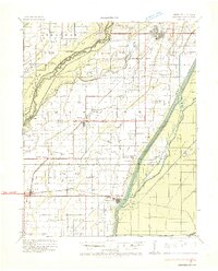
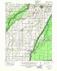
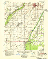
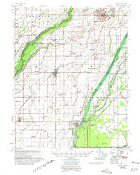
Kennett serves as the focal point of this mid-century Bootheel survey, showing the town's expansion and its reliance on the surrounding agricultural landscape. The region is defined by an intensive network of drainage infrastructure, such as the Grand Prairie Ditch and Elk Chute Ditch No 4, which turned formerly swampy lowlands into productive farmland. Settlement patterns follow the higher ground and rail lines, with established communities like Senath and Hornersville linked by the St Louis Southwestern RR. Rural life is anchored by numerous small social centers, evidenced by combined institutions like the Bucoda Ch & Sch and Allen Island Ch & Sch. The proximity of the St Francis River and the meandering Varney River create a complex boundary between Missouri and Arkansas, marked by isolated landforms such as Cypress Point Island and Lula Island.
Find a feature on this map
122 named features on this map. Tap any name to fly to it.
Don’t see what you’re looking for? This feature index may not catch every label — zoom into the map to look around manually.
Map Details
Editions of this 1956 Kennett Map
2 editions found
Historical Maps of Kennett Through Time
3 maps found