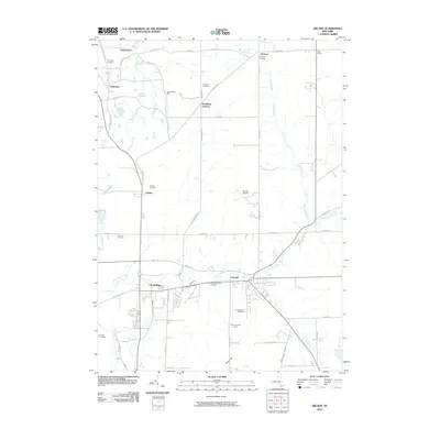
2010 Map of Arcade
USGS Topo · Published 2010About this map
Cattaraugus Creek and Clear Creek define the southern landscape of this Wyoming County region, where the village of Arcade serves as a primary hub. The map shows a transition from the structured residential blocks of Yorkshire and Arcade to the surrounding agricultural and rural residential tracts. Notable community landmarks include the Arcade Rural Cemetery and Saints Peter and Paul's Cemetery, reflecting the area's established local heritage. Small settlements like Dutchtown, Protection, and Punkshire Corners are scattered to the north, connected by a network of rural routes such as Genesee Rd and Chaffee Rd. Industrial and recreational interests are present through the Chaffee Gravel Pit and the Turkey Run Golf Course, while more specialized sites like the Arcade Airpark and Camp Merrie Mill sit tucked away in the more open countryside toward the north and west.
Find a feature on this map
60 named features on this map. Tap any name to fly to it.
Don’t see what you’re looking for? This feature index may not catch every label — zoom into the map to look around manually.
Map Details
Editions of this 2010 Arcade Map
This is the sole edition of this map. No revisions or reprints were ever made.
Other maps of this area

1923 · Arcade
USGS Topo · 1:62,500

1924 · Ellicottville
USGS Topo · 1:62,500

1924 · Franklinville
USGS Topo · 1:62,500

1925 · Springville
USGS Topo · 1:62,500

1925 · Arcade
USGS Topo · 1:62,500

1941 · Ellicottville
USGS Topo · 1:62,500

1942 · Franklinville
USGS Topo · 1:62,500
1955 · Holland
USGS Topo · 1:24,000

1957 · Sardinia
USGS Topo · 1:24,000
1957 · Strykersville
USGS Topo · 1:24,000