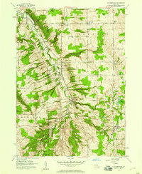
1957 Map of Strykersville
USGS Topo · Published 1958About this map
Buffalo Creek carves a deep valley through the Western New York landscape, anchoring a string of mid-century communities including Strykersville and Wales Hollow. This 1957 field-checked survey reveals a concentrated network of Catholic parish life, with parochial institutions like St Marys School, St Marys Cemetery, and St Caecilia School serving the farming families of Sheldon and Java. The upland terrain is punctuated by family-named landmarks like Weed Hill and Sanders Hill, while the lower elevations near Java Village show the early development of the Erie Co Reforestation Area. This survey documents a quiet rural economy defined by local gravel pits, scattered Gas Wells, and numerous one-room schoolhouses like School No. 1 and School No. 11 that were still landmarked features of the Wyoming County countryside.
Find a feature on this map
48 named features on this map. Tap any name to fly to it.
Don’t see what you’re looking for? This feature index may not catch every label — zoom into the map to look around manually.
Map Details
Editions of this 1957 Strykersville Map
2 editions found
Other maps of this area

1905 · Attica
USGS Topo · 1:62,500

1905 · Depew
USGS Topo · 1:62,500

1923 · Arcade
USGS Topo · 1:62,500

1925 · Springville
USGS Topo · 1:62,500

1925 · Arcade
USGS Topo · 1:62,500

1948 · Depew
USGS Topo · 1:62,500

1949 · Attica
USGS Topo · 1:62,500

1949 · Cowlesville
USGS Topo · 1:24,000
1949 · Attica
USGS Topo · 1:24,000
1950 · East Aurora
USGS Topo · 1:24,000