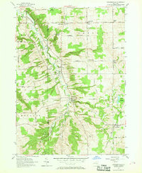
1957 Map of Strykersville
USGS Topo · Published 1969About this map
Buffalo Creek winds through the rural borderlands of Erie and Wyoming counties, anchoring a mid-century landscape of small agricultural hamlets and valley settlements. The village of Strykersville serves as a central hub, flanked by several religious and educational landmarks such as St Marys Sch and the adjacent St Marys Cem. The map reveals a pattern of tight-knit rural communities including Java Village and Sheldon Center, where the presence of multiple local schools like School No 1 and Sch No 11 reflects the decentralized civic life of the late 1950s. To the south, the Erie Co Reforestation Area indicates a shift toward conservation and managed woodlots amidst the traditional dairy-country hills. Local infrastructure is defined by a network of named ridge and valley roads, connecting outlying points like Frinks Corners and Plants Corners to the primary creek-side corridors.
Find a feature on this map
53 named features on this map. Tap any name to fly to it.
Don’t see what you’re looking for? This feature index may not catch every label — zoom into the map to look around manually.
Map Details
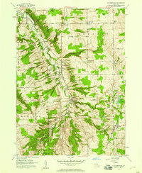
Editions of this 1957 Strykersville Map
2 editions found
Other maps of this area

1905 · Attica
USGS Topo · 1:62,500

1905 · Depew
USGS Topo · 1:62,500

1923 · Arcade
USGS Topo · 1:62,500

1925 · Springville
USGS Topo · 1:62,500

1925 · Arcade
USGS Topo · 1:62,500

1948 · Depew
USGS Topo · 1:62,500

1949 · Attica
USGS Topo · 1:62,500

1949 · Cowlesville
USGS Topo · 1:24,000
1949 · Attica
USGS Topo · 1:24,000
1950 · East Aurora
USGS Topo · 1:24,000