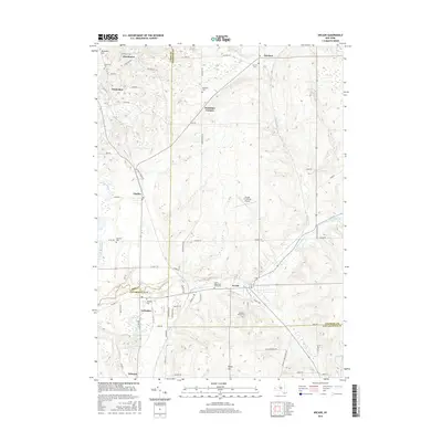
2016 Map of Arcade
USGS Topo · Published 2016About this map
Arcade and its surrounding tri-county borders serve as a primary hub in this Western New York survey, where the boundaries of Erie, Wyoming, and Cattaraugus counties converge. The village of Yorkshire and the larger settlement of Arcade occupy the southern portion of the sheet, while smaller hamlets like Chaffee, Protection, and Dutchtown follow the corridor north toward Vermont Hill. The landscape is characterized by a significant number of established burial grounds, including the Arcade Rural Cemetery and the Saints Peter and Pauls Cemetery, reflecting the deep-rooted community history of these townships.
Find a feature on this map
71 named features on this map. Tap any name to fly to it.
Don’t see what you’re looking for? This feature index may not catch every label — zoom into the map to look around manually.
Map Details
Editions of this 2016 Arcade Map
This is the sole edition of this map. No revisions or reprints were ever made.
Other maps of this area

1923 · Arcade
USGS Topo · 1:62,500

1924 · Ellicottville
USGS Topo · 1:62,500

1924 · Franklinville
USGS Topo · 1:62,500

1925 · Springville
USGS Topo · 1:62,500

1925 · Arcade
USGS Topo · 1:62,500

1941 · Ellicottville
USGS Topo · 1:62,500

1942 · Franklinville
USGS Topo · 1:62,500
1955 · Holland
USGS Topo · 1:24,000

1957 · Sardinia
USGS Topo · 1:24,000
1957 · Strykersville
USGS Topo · 1:24,000