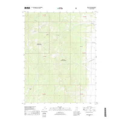
2018 Map of Arch Canyon
USGS Topo · Published 2018About this map
Lexington Arch stands as a prominent natural landmark within the high-elevation landscape of the Snake Range, where the eastern boundary of Great Basin National Park meets the Humboldt National Forest. This 2018 survey detail highlights a complex network of seasonal drainages and springs that define the local hydrology, including Cedar Cabin Spring, South Spring, and North Spring. The terrain is characterized by deep incisions such as Arch Canyon and Decathon Canyon, which channel snowmelt toward the desert floor. Road development remains sparse, centered primarily on the Black Canyon Rd and Natl Forest Develop Road 468 Rd, reflecting the managed conservation status of these public lands. This map is particularly useful for geologists and backcountry researchers interested in the drainage patterns of Lexington Cr and Chokecherry Cr.
Find a feature on this map
25 named features on this map. Tap any name to fly to it.
Don’t see what you’re looking for? This feature index may not catch every label — zoom into the map to look around manually.
Map Details
Editions of this 2018 Arch Canyon Map
This is the sole edition of this map. No revisions or reprints were ever made.
Other maps of this area

1948 · Wheeler Peak
USGS Topo · 1:62,500

1949 · Garrison
USGS Topo · 1:62,500

1950 · Wheeler Peak
USGS Topo · 1:62,500

1951 · Garrison
USGS Topo · 1:62,500

1956 · Lund
USGS Topo · 1:250,000

1960 · Lund
USGS Topo · 1:250,000
1972 · Tweedy Wash
USGS Topo · 1:24,000

1972 · Big Springs
USGS Topo · 1:24,000

1973 · Red Ledges
USGS Topo · 1:24,000
1979 · Garrison
USGS Topo · 1:100,000