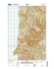
2014 Map of Arch Cape
USGS Topo · Published 2014About this map
Angora Peak and Onion Peak dominate the high ridges of the Northern Oregon Coast Range, overlooking the Pacific where the border between Clatsop and Tillamook counties meets the sea. This landscape is defined by the steep transition from timbered summits to the shoreline, where the highway traverses the Arch Cape Tunnel to connect isolated communities. Along the coast, distinctive rock formations like Castle Rock, Lion Rock, and Gull Rock mark the littoral zone between Cannon Beach and the southern reaches of Cape Falcon. Settlement patterns follow the narrow coastal terrace, with communities such as Arch Cape, Tolovana Park, and Cove Beach tucked between the mountains and the surf. To the south, the dramatic coastline gives way to Smuggler Cove and the churning waters of the Devils Cauldron, illustrating the geologic intensity of this stretch of the Pacific Northwest.
Find a feature on this map
60 named features on this map. Tap any name to fly to it.
Don’t see what you’re looking for? This feature index may not catch every label — zoom into the map to look around manually.
Map Details
Editions of this 2014 Arch Cape Map
This is the sole edition of this map. No revisions or reprints were ever made.
Other maps of this area

1937 · Nehalem
USGS Topo · 1:62,500

1940 · Cape Falcon
USGS Topo · 1:62,500

1943 · Nehalem
USGS Topo · 1:62,500

1948 · Vancouver
USGS Topo · 1:250,000

1949 · Tillamook Head
USGS Topo · 1:24,000

1950 · Vancouver
USGS Topo · 1:250,000

1950 · Vancouver
USGS Topo · 1:250,000

1955 · Nehalem
USGS Topo · 1:62,500
1955 · Cannon Beach
USGS Topo · 1:62,500

1958 · Vancouver
USGS Topo · 1:250,000