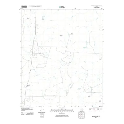
2010 Map of Archer City NE
USGS Topo · Published 2010About this map
The Little Wichita River meanders across this northern Texas landscape, defining a region where the traditional cattle ranching industry intersects with modern energy production. Significant tracts of land are held by established outfits such as the Mule Shoe Ranch, Coleman Ranch, and Edwards Ranch, illustrating the persistent ranching heritage of Archer County. This 2010 survey highlights the density of the local petroleum economy, showing expansive subterranean resources via the Scotland-Little Wichita Oil Field, Minton-Strawn Oil Field, and Chalk Hill Oil Field. The terrain is punctuated by small-scale water management features like Dillards Lake Dam, Mexican Tank, and Red Tank, which are essential for livestock in this semi-arid environment. Local travel is facilitated by rural connectors such as Coleman Rd and Davis Rd, linking the scattered ranches and oil operations throughout the quadrangle.
Find a feature on this map
24 named features on this map. Tap any name to fly to it.
Don’t see what you’re looking for? This feature index may not catch every label — zoom into the map to look around manually.
Map Details
Editions of this 2010 Archer City NE Map
This is the sole edition of this map. No revisions or reprints were ever made.
Other maps of this area

1931 · Archer City
USGS Topo · 1:62,500

1954 · Wichita Falls
USGS Topo · 1:250,000

1956 · Sloop Creek
USGS Topo · 1:24,000

1956 · Lake Wichita
USGS Topo · 1:24,000

1957 · Wichita Falls East
USGS Topo · 1:62,500

1957 · Wichita Falls West
USGS Topo · 1:62,500

1958 · Wichita Falls
USGS Topo · 1:250,000

1962 · Windthorst
USGS Topo · 1:24,000

1963 · Scotland
USGS Topo · 1:24,000
1963 · Archer City NE
USGS Topo · 1:24,000