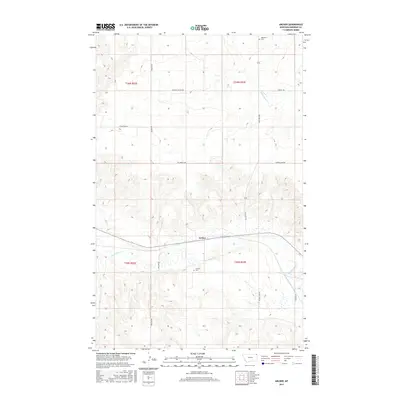
2017 Map of Archer
USGS Topo · Published 2017About this map
The small settlement of Archer sits at a crossroads in Sheridan County, Montana, defined by its position on a state highway and its proximity to the winding waters of Big Muddy Cr. The landscape is a textbook example of the Northern Plains, characterized by large-scale agricultural sections and a network of gravel section-line roads such as Grants Rd and Firehill Rd. Local history is anchored at the Archer Cem and Highland Cem, which serve as quiet landmarks for the rural community. To the north, the terrain is cut by Plentywood Cr and Mission Canyon Rd, illustrating the drainage patterns that shaped the early cattle and farming routes of this northeastern Montana borderland. The alignment of the Outlook Hwy through the center of the sheet highlights the transition toward modern infrastructure in this expansive prairie environment.
Find a feature on this map
19 named features on this map. Tap any name to fly to it.
Don’t see what you’re looking for? This feature index may not catch every label — zoom into the map to look around manually.
Map Details
Editions of this 2017 Archer Map
This is the sole edition of this map. No revisions or reprints were ever made.
Other maps of this area

1954 · Wolf Point
USGS Topo · 1:250,000

1958 · Wolf Point
USGS Topo · 1:250,000

1983 · Plentywood NW
USGS Topo · 1:24,000
1983 · Daleview
USGS Topo · 1:24,000

1983 · Outlook
USGS Topo · 1:24,000

1983 · Redstone
USGS Topo · 1:24,000

1983 · Kisler Butte
USGS Topo · 1:24,000

1983 · Soo NW
USGS Topo · 1:24,000

1983 · Archer
USGS Topo · 1:24,000
1983 · Soo NE
USGS Topo · 1:24,000