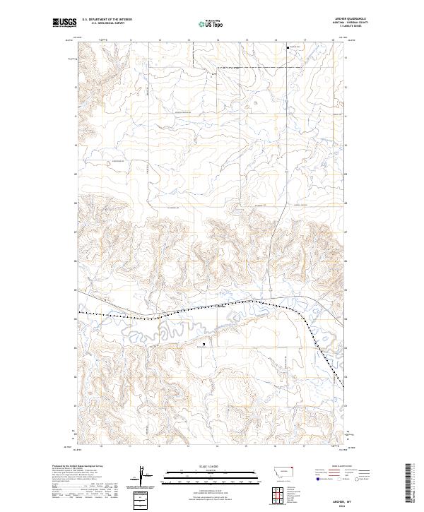
2024 Map of Archer
USGS Topo · Published 2024About this map
Archer serves as the central point of this Sheridan County landscape, where the grain-growing plains meet the winding course of Big Muddy Creek. This modern record illustrates a quiet corner of northeast Montana, defined by a strict grid of section lines and gravel roads that connect scattered farmsteads and rural infrastructure. The persistence of local history is visible in the placement of Archer Cem and Outlook Cem, which remain as long-standing markers of the early families who settled this region.
Find a feature on this map
18 named features on this map. Tap any name to fly to it.
Don’t see what you’re looking for? This feature index may not catch every label — zoom into the map to look around manually.
Map Details
Editions of this 2024 Archer Map
This is the sole edition of this map. No revisions or reprints were ever made.
Other maps of this area

1954 · Wolf Point
USGS Topo · 1:250,000

1958 · Wolf Point
USGS Topo · 1:250,000

1983 · Plentywood NW
USGS Topo · 1:24,000
1983 · Daleview
USGS Topo · 1:24,000

1983 · Outlook
USGS Topo · 1:24,000

1983 · Redstone
USGS Topo · 1:24,000

1983 · Kisler Butte
USGS Topo · 1:24,000

1983 · Soo NW
USGS Topo · 1:24,000

1983 · Archer
USGS Topo · 1:24,000
1983 · Soo NE
USGS Topo · 1:24,000