
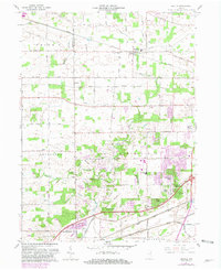
1961 Map of Arcola
USGS Topo · Published 1963About this map
The Treaty Line cuts a diagonal path through this southwestern portion of Allen County, marking an early nineteenth-century boundary that still influenced local property lines when this survey was conducted. The village of Arcola serves as a northern anchor, characterized by the Arcola Sch and the spiritual and communal center at St Patricks Ch and its accompanying St Patricks Cem. This era shows a landscape in transition, where established rural hamlets like Dunfee and Ellisville meet the post-war suburban growth of developments such as Liberty Hills, Manor Woods, and Rolling Hills.
Find a feature on this map
57 named features on this map. Tap any name to fly to it.
Don’t see what you’re looking for? This feature index may not catch every label — zoom into the map to look around manually.
Map Details
Editions of this 1961 Arcola Map
2 editions found
Other maps of this area

1953 · Fort Wayne
USGS Topo · 1:250,000

1953 · Muncie
USGS Topo · 1:250,000

1955 · Columbia City
USGS Topo · 1:24,000

1956 · Muncie
USGS Topo · 1:250,000

1956 · Fort Wayne
USGS Topo · 1:250,000

1956 · Fort Wayne West
USGS Topo · 1:24,000

1956 · Huntington
USGS Topo · 1:24,000

1957 · Huntertown
USGS Topo · 1:24,000

1957 · Churubusco
USGS Topo · 1:24,000
1961 · Laud
USGS Topo · 1:24,000