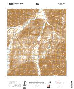
2018 Map of Arctic C-5 NW
USGS Topo · Published 2018About this map
The Ivishak River defines the central axis of this North Slope landscape, carving through the high-elevation terrain of the Arctic C-5 NW region. This 2018 survey emphasizes the immense vertical relief and drainage patterns within the northern reaches of the Brooks Range, where the river channel serves as the primary topographical landmark across the township boundaries of T8s R22e, T8s R23e, T9s R22e, and T9s R23e. The map highlights a wilderness virtually untouched by permanent settlements or road infrastructure, focusing instead on the precise contouring of the peaks and valleys that feed into the Ivishak system. It is a critical document for understanding the hydrological flow and natural surveying divisions in one of the most remote sections of the North Slope Borough.
Find a feature on this map
5 named features on this map. Tap any name to fly to it.
Don’t see what you’re looking for? This feature index may not catch every label — zoom into the map to look around manually.
Map Details
Editions of this 2018 Arctic C-5 NW Map
This is the sole edition of this map. No revisions or reprints were ever made.
Other maps of this area

1951 · Brooks
USGS Topo · 1:250,000

1951 · Arctic
USGS Topo · 1:250,000

1956 · Arctic
USGS Topo · 1:250,000

1956 · Philip Smith Mountains
USGS Topo · 1:250,000

1964 · Philip Smith Mountains
USGS Topo · 1:250,000
1971 · Arctic D-5
USGS Topo · 1:63,360
1971 · Philip Smith Mountains C-1
USGS Topo · 1:63,360
1971 · Arctic C-5
USGS Topo · 1:63,360
1971 · Philip Smith Mountains D-1
USGS Topo · 1:63,360
2017 · Philip Smith Mountains D-1 SE
USGS Topo · 1:25,000