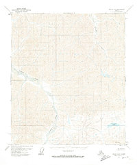
1971 Map of Arctic D-5
USGS Topo · Published 1973About this map
Ivishak River and the Echooka River dominate this 1971 study of the Alaskan North Slope, captured just as interest in the region's resource potential was intensifying. The map, based on 1970 aerial photography, reveals an unpeopled landscape of sharp elevation changes and braided river systems. The Bureau of Land Management predetermined land lines for this unsurveyed territory, which includes distinctive landmarks like Mt Annette and the secluded Porcupine Lake in the southeast corner. The terrain is marked by prominent peaks such as Echo, illustrating the isolation of the Brooks Range foothills during the early 1970s. This USGS record provides a baseline for the region before any modern industrial footprints or trails were established in this specific quadrangle.
Find a feature on this map
5 named features on this map. Tap any name to fly to it.
Don’t see what you’re looking for? This feature index may not catch every label — zoom into the map to look around manually.
Map Details
Editions of this 1971 Arctic D-5 Map
This is the sole edition of this map. No revisions or reprints were ever made.
Other maps of this area

1951 · Sagavanirktok D-5
USGS Topo · 1:250,000

1951 · Brooks
USGS Topo · 1:250,000

1951 · Arctic
USGS Topo · 1:250,000

1951 · Mt. Michelson
USGS Topo · 1:250,000

1956 · Arctic
USGS Topo · 1:250,000

1956 · Mt. Michelson
USGS Topo · 1:250,000

1956 · Philip Smith Mountains
USGS Topo · 1:250,000

1956 · Sagavanirktok
USGS Topo · 1:250,000

1958 · Sagavanirktok
USGS Topo · 1:250,000

1964 · Philip Smith Mountains
USGS Topo · 1:250,000