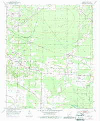
1951 Map of Arden
USGS Topo · Published 1987About this map
Arden serves as a focal point in this Little River County landscape, where the St Louis San Francisco railroad cuts through the terrain. The map captures a rural Arkansas community shaped by its schools and houses of worship, featuring Nolen Sch and several churches including St John Ch, St Rest Ch, and Wade Chapel. The agricultural and timber character of the region is evident in the broad expanses of Burke Flats and Gum, while the southern boundary is defined by the winding course of the Red River. Smaller water features like Walnut Bayou and Horseshoe Slough indicate the low-lying, often marshy nature of the river bottomlands. For genealogists, the inclusion of small family or community burial sites like Pine Grove Cem, Bradshaw Cem, and Hemphill Cem provides specific locations for historical research in the areas surrounding Wallace and Pankov.
Find a feature on this map
24 named features on this map. Tap any name to fly to it.
Don’t see what you’re looking for? This feature index may not catch every label — zoom into the map to look around manually.
Map Details
Editions of this 1951 Arden Map
4 editions found

Other maps of this area

1950 · Redbank
USGS Topo · 1:24,000

1950 · Ashdown West
USGS Topo · 1:24,000

1950 · Barkman
USGS Topo · 1:24,000

1950 · Falls Chapel
USGS Topo · 1:24,000

1950 · Winthrop
USGS Topo · 1:24,000

1951 · Winthrop
USGS Topo · 1:24,000

1951 · Redbank
USGS Topo · 1:24,000

1951 · Ashdown West
USGS Topo · 1:24,000

1951 · Falls Chapel
USGS Topo · 1:24,000

1951 · Barkman
USGS Topo · 1:24,000