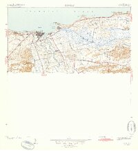
1942 Map of Arecibo
USGS Topo · Published 1942About this map
The coastal sugar and shipping economy of northern Puerto Rico is centered here on the Rio Grande de Arecibo, where the river meets the Atlantic Ocean at the historic port of Arecibo. This 1940s landscape is dominated by the massive industrial footprint of Central Cambalache, a major sugar mill served by the American Railroad of Porto Rico. The rail line threads through the valley, connecting Estacion Arecibo and Estacion Cambalache with the surrounding agricultural lands.
Find a feature on this map
40 named features on this map. Tap any name to fly to it.
Don’t see what you’re looking for? This feature index may not catch every label — zoom into the map to look around manually.
Map Details
Editions of this 1942 Arecibo Map
2 editions found
Other maps of this area

1938 · Camuy
USGS Topo · 1:20,000

1942 · Arecibo
USGS Topo · 1:30,000

1942 · Camuy
USGS Topo · 1:30,000

1942 · Barceloneta
USGS Topo · 1:30,000

1943 · Utuado NE
USGS Topo · 1:10,000

1946 · Barceloneta
USGS Topo · 1:30,000

1946 · Utuado
USGS Topo · 1:30,000

1946 · Bayaney
USGS Topo · 1:30,000

1946 · Arecibo
USGS Topo · 1:30,000

1946 · Florida
USGS Topo · 1:30,000
Featured Places
- Arecibo
- Ballajá, Arecibo
- Reparto Los Maestros, Arecibo
- Sector Pueblo de Paja, Arecibo
- El Colloral, Arecibo