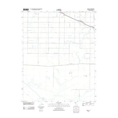
2012 Map of Arena
USGS Topo · Published 2012About this map
Agricultural infrastructure and water management define the landscape near Arena in this 2012 survey of the San Joaquin Valley. The region is crisscrossed by an intricate network of irrigation channels, including the Arena Canal, Lehner Lateral, and Middle Dallas Lateral, which support the intensive local dairy industry. Major operations such as the Gallo Cottonwood Dairy and Gallo Colombard Dairy are central to the area's economy, situated north of the meandering course of Bear Cr. The layout of the land follows a strict grid of rural thoroughfares like Lincoln Blvd and McSwain Rd, reflecting a century of systematic land development. This map captures the intersection of natural hydrology and engineered utility, where the Livingston Drain and various laterals manage the flow of water across the fertile Merced County plains.
Find a feature on this map
50 named features on this map. Tap any name to fly to it.
Don’t see what you’re looking for? This feature index may not catch every label — zoom into the map to look around manually.
Map Details
Editions of this 2012 Arena Map
This is the sole edition of this map. No revisions or reprints were ever made.
Other maps of this area

1916 · Cressey
USGS Topo · 1:31,680

1917 · Turlock
USGS Topo · 1:31,680

1917 · Winton
USGS Topo · 1:31,680

1918 · Arena
USGS Topo · 1:31,680

1918 · Atwater
USGS Topo · 1:31,680

1918 · Stevinson
USGS Topo · 1:31,680

1918 · Sandy Mush
USGS Topo · 1:31,680

1918 · Turner Ranch
USGS Topo · 1:31,680

1919 · San Luis Ranch
USGS Topo · 1:31,680
1942 · Irwin
USGS Topo · 1:62,500