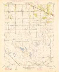
1948 Map of Arena
USGS Topo · Published 1948About this map
The agricultural landscape of Merced County during the late 1940s is defined by an intricate network of irrigation ditches and rural roads radiating from the Southern Pacific railroad corridor. While Atwater anchors the eastern edge of the survey, the small community of Arena serves as a local hub for the surrounding fields, supported by the Arena Sch and Jordan Sch. The map reveals a highly engineered environment where natural waterways like Bear Creek and South Bear Creek coexist with man-made features such as the Atwater Canal and numerous named laterals like the Fruitland Lateral. This grid-based development, overseen by state engineers like Edward Hyatt and Director of Public Works C. H. Purcell, reflects the mid-century transition of the Central Valley into a powerhouse of organized irrigation. Many family-named thoroughfares, including McGinley Lateral and Martin Lateral, provide genealogical clues to the landholders of this era.
Find a feature on this map
27 named features on this map. Tap any name to fly to it.
Don’t see what you’re looking for? This feature index may not catch every label — zoom into the map to look around manually.
Map Details
Editions of this 1948 Arena Map
This is the sole edition of this map. No revisions or reprints were ever made.
Other maps of this area

1916 · Cressey
USGS Topo · 1:31,680

1917 · Turlock
USGS Topo · 1:31,680

1917 · Winton
USGS Topo · 1:31,680

1918 · Arena
USGS Topo · 1:31,680

1918 · Atwater
USGS Topo · 1:31,680

1918 · Stevinson
USGS Topo · 1:31,680

1918 · Sandy Mush
USGS Topo · 1:31,680

1918 · Turner Ranch
USGS Topo · 1:31,680

1919 · San Luis Ranch
USGS Topo · 1:31,680
1942 · Irwin
USGS Topo · 1:62,500