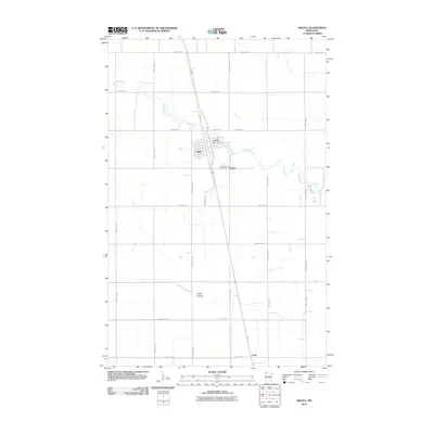
2010 Map of Argyle
USGS Topo · Published 2010About this map
Argyle stands as the central hub of this Marshall County landscape, where the Middle River winds through a structured grid of rural roads and section lines. The town's layout is defined by the intersection of Pacific Ave and Bridge Ave, with the Middle River Dam controlling the water's flow just east of the main settlement. This area of northwest Minnesota is deeply rooted in local heritage, evidenced by the presence of Saint Rose Cemetery and Woodlawn Cemetery situated along River St. The surrounding countryside is characterized by drainage patterns like Swift Coulee and a vast network of numbered routes, including County Hwy-108 and County Hwy-33. To the south, the small siding or locale of Luna appears along the railroad corridor, reflecting the region's historical reliance on rail transport for its agricultural economy.
Find a feature on this map
26 named features on this map. Tap any name to fly to it.
Don’t see what you’re looking for? This feature index may not catch every label — zoom into the map to look around manually.
Map Details
Editions of this 2010 Argyle Map
This is the sole edition of this map. No revisions or reprints were ever made.
Other maps of this area

1918 · Angus
USGS Topo · 1:62,500

1918 · Argyle
USGS Topo · 1:62,500

1918 · Warren
USGS Topo · 1:62,500

1952 · Thief River Falls
USGS Topo · 1:250,000

1954 · Stephen
USGS Topo · 1:62,500

1955 · Warren
USGS Topo · 1:62,500

1956 · Thief River Falls
USGS Topo · 1:250,000

1956 · Florian
USGS Topo · 1:62,500

1957 · Thief River Falls
USGS Topo · 1:250,000
1961 · Roan
USGS Topo · 1:24,000