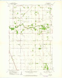
1961 Map of Roan
USGS Topo · Published 1963About this map
The Snake River meanders across this northwestern Minnesota landscape, defining the character of the borderlands between Marshall and Polk counties in the early 1960s. This survey illustrates a rural region organized by townships like McCrea and Brislet, where the drainage patterns of the South Branch Snake River intersect with the rigid geometry of sectional surveying and rail corridors. The settlement of Roan serves as a focal point along the Great Northern railroad, reflecting the importance of transportation to these farming communities.
Find a feature on this map
13 named features on this map. Tap any name to fly to it.
Don’t see what you’re looking for? This feature index may not catch every label — zoom into the map to look around manually.
Map Details
Editions of this 1961 Roan Map
2 editions found
Other maps of this area

1918 · Angus
USGS Topo · 1:62,500

1918 · Argyle
USGS Topo · 1:62,500

1918 · Warren
USGS Topo · 1:62,500

1952 · Thief River Falls
USGS Topo · 1:250,000

1954 · Stephen
USGS Topo · 1:62,500

1955 · Warren
USGS Topo · 1:62,500

1956 · Thief River Falls
USGS Topo · 1:250,000

1956 · Florian
USGS Topo · 1:62,500

1957 · Thief River Falls
USGS Topo · 1:250,000

1961 · Radium
USGS Topo · 1:24,000