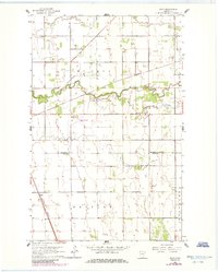
1961 Map of Roan
USGS Topo · Published 1985About this map
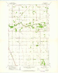
The Snake River meanders across this Red River Valley landscape, joined by its South Branch near the center of the survey area. At the dawn of the 1960s, this region remained a critical rail corridor, anchored by the Soo Line and Burlington Northern railroads which slice through the prairie. The small settlement of Roan sits near the southwestern corner, reflecting the rural character of the borderlands between Marshall and Polk Counties. The presence of the Warren Municipal Airport and several Gravel Pits north of the river indicates the local infrastructure and industry of the era. The land is organized into the townships of McCrea, Brislet, and Helgeland, showing a classic midwestern section-line road grid that defines the agricultural geometry of Northwest Minnesota.
Find a feature on this map
12 named features on this map. Tap any name to fly to it.
Don’t see what you’re looking for? This feature index may not catch every label — zoom into the map to look around manually.
Map Details
Editions of this 1961 Roan Map
2 editions found
Other maps of this area

1918 · Angus
USGS Topo · 1:62,500

1918 · Argyle
USGS Topo · 1:62,500

1918 · Warren
USGS Topo · 1:62,500

1952 · Thief River Falls
USGS Topo · 1:250,000

1954 · Stephen
USGS Topo · 1:62,500

1955 · Warren
USGS Topo · 1:62,500

1956 · Thief River Falls
USGS Topo · 1:250,000

1956 · Florian
USGS Topo · 1:62,500

1957 · Thief River Falls
USGS Topo · 1:250,000

1961 · Radium
USGS Topo · 1:24,000