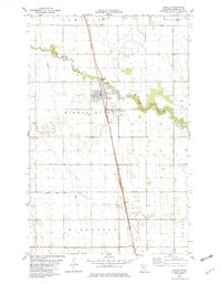
1982 Map of Argyle
USGS Topo · Published 1982About this map
Argyle serves as the central hub of this Red River Valley landscape, situated where the Burlington Northern railroad intersects the meandering path of the Middle River. The town's layout and surrounding agriculture are defined by water management and transport, visible in the extensive network of drainage channels like County Ditch No 3 and Judicial Ditch No 20. These engineered waterways contrast with the natural curves of Swift Coulee to the south.
Find a feature on this map
20 named features on this map. Tap any name to fly to it.
Don’t see what you’re looking for? This feature index may not catch every label — zoom into the map to look around manually.
Map Details
Editions of this 1982 Argyle Map
This is the sole edition of this map. No revisions or reprints were ever made.
Other maps of this area

1918 · Angus
USGS Topo · 1:62,500

1918 · Argyle
USGS Topo · 1:62,500

1918 · Warren
USGS Topo · 1:62,500

1952 · Thief River Falls
USGS Topo · 1:250,000

1954 · Stephen
USGS Topo · 1:62,500

1955 · Warren
USGS Topo · 1:62,500

1956 · Thief River Falls
USGS Topo · 1:250,000

1956 · Florian
USGS Topo · 1:62,500

1957 · Thief River Falls
USGS Topo · 1:250,000
1961 · Roan
USGS Topo · 1:24,000