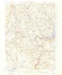
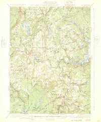
1932 Map of Ariel
USGS Topo · Published 1942About this map
Lake Ariel and the surrounding plateau regions of Wayne County define this 1932 landscape, which was surveyed just as the regional water systems were being transformed. The massive Wallenpaupack Lake dominates the eastern edge, its intricate shoreline cutting into the townships of Palmyra and Greene. This era shows a dense network of local civic life, with dozens of family-named schools like Frisbie Sch and Brown Sch serving rural crossroads.
Find a feature on this map
122 named features on this map. Tap any name to fly to it.
Don’t see what you’re looking for? This feature index may not catch every label — zoom into the map to look around manually.
Map Details
Editions of this 1932 Ariel Map
3 editions found

Other maps of this area

1889 · Scranton
USGS Topo · 1:62,500

1891 · Scranton
USGS Topo · 1:62,500

1892 · Honesdale
USGS Topo · 1:62,500

1892 · Dundaff
USGS Topo · 1:62,500

1893 · Scranton
USGS Topo · 1:62,500

1919 · Pocono
USGS Topo · 1:62,500

1920 · Damascus
USGS Topo · 1:62,500

1921 · Pocono
USGS Topo · 1:62,500

1922 · Stoddartsville
USGS Topo · 1:62,500

1923 · Damascus
USGS Topo · 1:62,500
Featured Places
- Cherry Ridge Township, PA
- South Canaan Township, PA
- Sterling Township, PA
- Clifton Township, PA
- Lake Township, PA