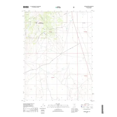
2018 Map of Arizona Spring
USGS Topo · Published 2018About this map
The East Humboldt Range defines the western terrain of this Elko County region, where the high-elevation peaks drop into the expansive Clover Valley. Managed largely as part of the Humboldt National Forest, the landscape is defined by its water sources and rugged transit routes. Vital water points such as Arizona Spring, Curtis Spring, and Government Spring sustain the area, while the drainage of Outhouse Draw and Ruby City Creek channel snowmelt toward the valley floor. Transportation is primarily facilitated by specialized routes and forest roads, including the Natl Forest Develop Road 507 Rd and various spurs like Polar Star. The nomenclature of the area, featuring labels like Warm Spring N and Warm Spring S, highlights the importance of thermal and seasonal water features to the local geography and historical land use patterns.
Find a feature on this map
28 named features on this map. Tap any name to fly to it.
Don’t see what you’re looking for? This feature index may not catch every label — zoom into the map to look around manually.
Map Details
Editions of this 2018 Arizona Spring Map
This is the sole edition of this map. No revisions or reprints were ever made.
Other maps of this area

1935 · Halleck
USGS Topo · 1:125,000

1953 · Spruce Mountain
USGS Topo · 1:62,500

1955 · Elko
USGS Topo · 1:250,000

1958 · Elko
USGS Topo · 1:250,000

1962 · Elko
USGS Topo · 1:250,000

1965 · Elko
USGS Topo · 1:250,000

1968 · Snow Water Lake
USGS Topo · 1:24,000
1969 · Secret Valley
USGS Topo · 1:24,000
1969 · Gordon Creek
USGS Topo · 1:24,000
1984 · Arizona Spring
USGS Topo · 1:24,000