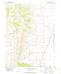
1969 Map of Gordon Creek
USGS Topo · Published 1973About this map
Humboldt National Forest encompasses the high ridges of the East Humboldt Range, where numerous water sources like Woolverton Spring and Agee Spring feed a network of drainages including Gordon Creek and Wiseman Creek. To the east, the terrain drops sharply into the Clover Valley, a distinct topographical basin containing the southern reaches of Snow Water Lake. This transition from high-altitude forest to the valley floor is marked by a concentration of vital water points for cattle and wildlife.
Find a feature on this map
30 named features on this map. Tap any name to fly to it.
Don’t see what you’re looking for? This feature index may not catch every label — zoom into the map to look around manually.
Map Details
Editions of this 1969 Gordon Creek Map
This is the sole edition of this map. No revisions or reprints were ever made.
Other maps of this area

1935 · Halleck
USGS Topo · 1:125,000

1953 · Spruce Mountain
USGS Topo · 1:62,500

1955 · Elko
USGS Topo · 1:250,000

1958 · Elko
USGS Topo · 1:250,000

1962 · Elko
USGS Topo · 1:250,000

1965 · Elko
USGS Topo · 1:250,000

1968 · Snow Water Lake
USGS Topo · 1:24,000
1968 · Tobar
USGS Topo · 1:24,000
1969 · Secret Valley
USGS Topo · 1:24,000
1969 · Humboldt Peak
USGS Topo · 1:24,000