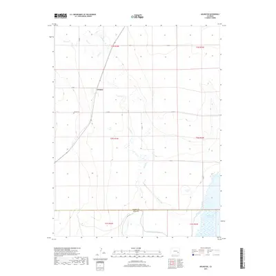
2019 Map of Arlington
USGS Topo · Published 2019About this map
Arlington sits at the heart of this high plains landscape, defined by a critical network of water management infrastructure where the Kiowa and Bent county lines meet. The settlement is anchored near the Arlington Cem, while the surrounding terrain is heavily shaped by irrigation and storage projects including the Colt Ditch, Adobe Cr, and the substantial Fort Lyon Storage Canal. This 2019 survey documents the vital relationship between the arid environment and the engineering required to sustain it, particularly through the Adobe Cr Inlet which feeds into the massive Adobe Creek Reservoir in the southeast corner. The grid of county roads, such as Co RD 9 and Co RD E, reveals a sparse but organized agricultural settlement pattern typical of the eastern Colorado prairies.
Find a feature on this map
24 named features on this map. Tap any name to fly to it.
Don’t see what you’re looking for? This feature index may not catch every label — zoom into the map to look around manually.
Map Details
Editions of this 2019 Arlington Map
This is the sole edition of this map. No revisions or reprints were ever made.
Other maps of this area

1891 · Las Animas
USGS Topo · 1:125,000

1893 · Las Animas
USGS Topo · 1:125,000

1954 · Lamar
USGS Topo · 1:250,000

1955 · Mc Intosh Ranch
USGS Topo · 1:24,000

1955 · Bishop Ranch
USGS Topo · 1:24,000
1955 · Lewis Ranch
USGS Topo · 1:24,000

1958 · Lamar
USGS Topo · 1:250,000

1974 · Haswell
USGS Topo · 1:24,000

1974 · Arlington NE
USGS Topo · 1:24,000
1978 · Long Lake
USGS Topo · 1:24,000