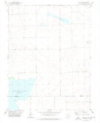
1978 Map of Long Lake
USGS Topo · Published 1978About this map
Adobe Creek Reservoir (Blue Lake) dominates the southwestern landscape of this High Plains region, where the border between Kiowa Co and Bent Co cuts across the water's surface at an elevation of 4,128 feet. This 1978 survey highlights a sparsely populated area defined by essential water management and land use, featuring the elongated basin of Long Lake to the north and the smaller Potters Lake on the eastern edge. The map records a functional landscape of section lines and fence lines, with infrastructure supporting local recreation and industry, such as a designated Picnic Area near the reservoir and a remote Drill Hole in the central plains. This topographic study reflects the era's reliance on aerial photogrammetry to document the subtle relief and vital water resources of the Colorado prairie.
Find a feature on this map
6 named features on this map. Tap any name to fly to it.
Don’t see what you’re looking for? This feature index may not catch every label — zoom into the map to look around manually.
Map Details
Editions of this 1978 Long Lake Map
This is the sole edition of this map. No revisions or reprints were ever made.
Other maps of this area

1891 · Las Animas
USGS Topo · 1:125,000

1893 · Las Animas
USGS Topo · 1:125,000

1954 · Lamar
USGS Topo · 1:250,000

1955 · Tree Top Ranch
USGS Topo · 1:24,000

1955 · Mc Intosh Ranch
USGS Topo · 1:24,000

1955 · Bishop Ranch
USGS Topo · 1:24,000

1958 · Lamar
USGS Topo · 1:250,000

1974 · Haswell
USGS Topo · 1:24,000
1974 · Haswell SE
USGS Topo · 1:24,000

1974 · Arlington NE
USGS Topo · 1:24,000